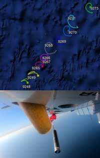
Tropical Globe has live reconnaissance in the Atlantic, East Pacific and Central Pacific basins for the U.S. Air Force and NOAA hurricane hunters. Dropsonde data from the NASA Global Hawk is also available when the data is relayed in the same way as NOAA dropsondes. Sometimes dropsonde data is also available in the West Pacific near Taiwan as part of Taiwan's DOTSTAR (Dropwindsonde Observations for Typhoon Surveillance near the Taiwan Region) project.
For a tutorial on how to use our recon system, and for additional informative info, such as on some of the aircraft used in reconnaissance, click here.
National Hurricane Center's (NHC) Aircraft Reconnaissance
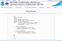
The Plan of the Day details planned recon missions. To view how to read the Plan of the Day, click here. The Plan of the Day is often released around 11am to noon Eastern time daily during the hurricane season. The "For Tomorrow" link contains the most recently released Plan of the Day. The "For Today" link is the prior issued Plan of the Day, usually from the previous day. If a Plan of the Day is corrected, then both links might have data from the same day. You can view older plans here if that happens.
We also include the contents of the "About the Reconnaissance Plan of the Day" page noted above:
These are the definitions for the fields A-G of the Aircraft Reconnaissance Plan of the Day.
Summer Plan:
A. Fix / Invest Time
B. Mission Identifier
C. Departure Time
D. Forecast Position
E. Time on Station
F. Altitude(s) on Station
G. Remarks (if needed)
Winter Plan:
A. Track / Control Point / Time
B. Mission Identifier
C. Departure Time
D. Drops Required / Added Positions
E. Altitude / Expiration Time
F. Remarks (if needed)
Source: National Hurricane Operations Plan, Office of the Federal Coordinator for Meteorological Services and Supporting Research, (FCM-P12-2003), U.S. Department of Commerce / National Oceanic and Atmospheric Administration.
In this near real-time archive you can access raw text data from the NHC from 1989 to the present. It might take about 15 to 30 minutes before data appears in the archive.
The 53rd Weather Reconnaissance Squadron (view Wikipedia entry) is part of the 403rd Wing (view Wikipedia entry), part of the U.S. Air Force. You can view a fact sheet here about the Air Force hurricane hunters. For news, click here to view news articles on the Air Force's website. You can view an article here about the coordination between the hurricane hunters and the NHC.
NASA has an unmanned aircraft system (UAS), the Global Hawk, which can fly up to about 24 hours over a storm. NASA also has other aircraft used in tropical research missions that our site does not track. You can track NASA aircraft here.
Example of their front page when at least one mission is active.
They have excellent imagery that displays flight track data, with flight level wind barbs, on maps with satellite imagery. They also have charts that graph various observations, such as extrapolated surface pressures, flight level winds and estimated surface winds (SFMR). They also have dropsonde data as well, including a map of the location of the sondes.
An example of one of the pages containing data.
The Imaging Wind and Rain Airborne Profiler (IWRAP), "which is also known as the Advanced Wind and Rain Airborne Profile (AWRAP), consists of two dual-polarized, dual-incidence angle radar profilers operating at Ku- and C-bands, and measures profiles of volume reflectivity and Doppler velocity of precipitation, as well as ocean surface backscatter. For more information regarding the use of IWRAP during this year’s HFP, please refer to the following three NESDIS Ocean Winds, Waves, and Precipitation Experiment documents in the Mature Stage Experiment: Science Goals & Observational Applications, Science Description, and Flight Pattern Descriptions." (quote from 2024 NOAA/AOML/HRD Hurricane Field Program; PDF file)
An example of a visualization from the "Interactive 3D Winds and Sondes" page.
For more information on IWRAP, see the following information: NESDIS STAR Ocean Winds Experiment (2022; PDF file)
Their site includes various interactive visualizations, some in 3-D, such as Interactive Sondes (storm centered SFMR and dropsonde wind plots), Interactive 3-D Winds and Sondes and Interactive Wind Profiles. It might only be available for one of NOAA's P-3's, N42RF ("Kermit"). When looking at data for Beryl in 2024, only N42RF seemed to have data for IWRAP.
You can read an article here and watch a video here with an interview from a scientist that had written code that was used in the software involved.
Data from an additional instrument, Ka-band Interferometric Altimeter (KaIA), is also available. It measures significant wave heights. A quote from the same PDF file that had the other quote says the following about it: "KaIA is a next generation centimetric radar altimeter that provides real-time observations of
significant wave height (SWH) of the ocean surface. The instrument is nadir-looking and operates
at Ka and Ku bands. KaIA also has the capability to retrieve mean squared slope (MSS), relative
ocean height, and wind speed estimates at low wind speeds."
Other Sites to Access Decoded U.S. Air Force and NOAA Recon Data
These sites also contain decoded reconnaissance data. As with our site, they may contain errors and may not be available at times.
CyclonicWx - HDOBs on map, dropsonde data and charts
This site contains additional information and data for NOAA recon. The "Hurricane Data" section on the page we link to has links to data from various years. Sometimes that section may not be updated to reflect the current year even though data is available. Use the links below if needed. (In 2024 when we checked one of the pages, the year was wrong even though current data was available)
You can view their older site from 2021 and earlier here. The new site still links to some of the older data there.
The links above may not work if it is too early in the year and the page has not yet been created.
If there is data for the current year, click the link to either the "Field Program Page" for general information or the "Hurricane Data Page" for actual data. On the data page you can then select a storm and then a mission to get additional data, such as a flight plan for G-IV missions.
Chapter 5 and Appendix G of the National Hurricane Operations Plan can be read for an understanding of how our site's recon system works.
Historical versions of NHOP, from 1967 to 2024, can be found on our Google Drive here. Since a reorganization of their site, prior years were hard to find so we decided to offer them.
We found older NHOPs from 1967 to 2004 on the site here
This is a research paper about the estimated reduction factors that can help estimate the surface winds in storms based on flight level winds. This table is from that research paper. "Table 2" is the "Recommended operational wind adjustment factors for adjusting reconnaissance flight-level winds to the surface, for the hurricane-eyewall and outer-vortex regions". You can view the paper here.
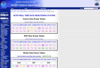
This National Centers for Environmental Prediction (NCEP) page has links that can let you know how many dropsondes have been added into the GFS. Once on the page above, look for "Model Data Dump Tables".
If you want to simply view the number of sondes that have been added into the particular run, click "GFS" next to "View the latest model data text summary". On the next page, look for "dropw", which is "Dropwinsonde (from TEMP DROP)". You will see the number added under the "Hourly Count" column.
If you want to see the number of sondes added for that particular run each day over the past month, in a graph, go back to the "Model Data Dump Tables" section on the original page. Under "GFS", click the run you want to look at. (00z, 06z, 12z or 18z) On the next page, click "dropw". You will see a chart that has the count added for each day for that particular GFS run you are looking at. The monthly average count is also available for that run, which was also available on the previous page noted. The page here says that dropsonde data is "usually from TPC or USAF (CARCAH) or occasionally from non U.S. sources".
The product with the header "NOUS42 KWNO" might also sometimes tell you about dropsonde data. You can access it at any of the following links. "ADMSDM" below is for Administrative Messages from the Senior Duty Meteorologist (SDM).
This product was previously "ADMNFD". In 2020 it changed to ADASDM (Alert Administrative Message) and ADMSDM (Administrative Message), but kept the same WMO header, "NOUS42 KWNO". Because only one message is displayed at a time for some sites, an archive is helpful. On an archive page, search within the page by pressing the "Ctrl + F" keys to search for the word "sonde" among all the messages for the month. You can also find an archive on this site, where messages are grouped by month.
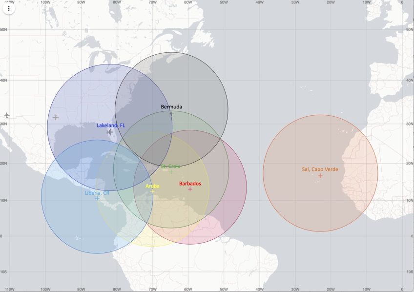
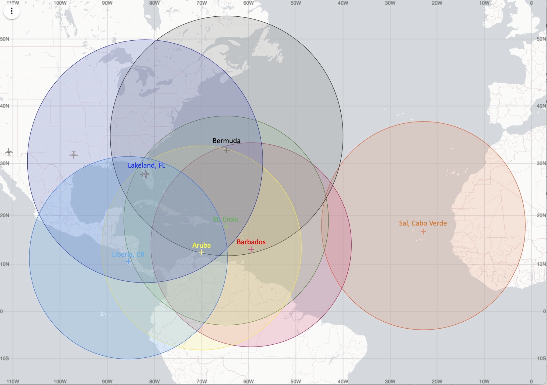
These operational flight maps come from AOML's site. Operational maps exist for the two P-3 aircraft (N42RF, "Kermit", and N43RF, "Miss Piggy") that flies into storms and the one Gulfstream IV aircraft (N49RF, "Gonzo") that flies around storms sampling the upper air environment.
We include them here in case the data is moved. Click an image to view a larger version. Each year they usually upload new images. Sometimes the operating bases change. In 2024 they are Lakeland, Florida; St. Croix, U.S. Virgin Islands; Barbados; Aruba; Bermuda; Liberia, Costa Rica; Sal, Cabo Verde.
Section from page containing NOAA flight patterns.
Example of Figure 4 for P-3 and G-IV.
You can also view a PDF of NOAA's flight patterns here from the 2024 Hurricane Field Program Appendix A (PDF file). We also have a copy here on our site in case that link changes.
The Figure 4 example is described in the PDF file like this:
In-Pattern Duration: ~ 2 h 15 min (P-3), ~ 1 h 20 min (G-IV)
Leg Lengths: 105 n mi (195 km)
Dropsondes: centers, mid-points and turn points of each leg [10 sondes total]
This site contains data for NOAA aircraft. There is a massive amount of raw data available on this server and some of that data is available in real time. This site is where our site used to get NOAA P-3 radar data from, before their lower fuselage radar was upgraded and the data was no longer available in a format our site could easily process.
If NOAA observations do not appear to be transmitted to the places they normally are, you may want to try going to the "sent" directory here. An archive of some of the observations from NOAA P-3 and G-IV aircraft exists there, with each folder name reflecting a particular mission in which you can find obs in. The first 8 digits of the folder name are the date group. The next character is the aircraft type (H: N42RF; I: N43RF; N: N49RF) and then a flight number that is probably there to separate multiple missions that occur on the same day for that aircraft. (though sometimes the numbering starts with 0 and sometimes 1) You may also find obs for a short period of time in the "incoming" folder here before they are removed.
Top: Screenshot from Google Earth of ALAMO floats deployed for Hurricane Teddy in 2020. Bottom: Test deployment of ALAMO float from P-3 aircraft. (Credit: NOAA)
The hurricane hunters will at times drop these floats from their aircraft. "The floats will measure temperature, salinity, and pressure in the upper 300 m of the ocean, profiling every 1-2 hours for several weeks."
You can view current ALAMO float data in Google Earth by downloading the file here.
You can view an article about them here. The article is from March 2021 and is about when NOAA was testing them. You can view a short YouTube clip here which shows one being dropped. The Air Force hurricane hunters have already been using these.
These can be dropped ahead of a storm so that they can measure the water temperature before and after passage of a storm. These floats allow for depth profiles to be taken repeatedly. From the documentation in a PDF file here, it "is capable of 200 cycles to 1200 meters".
You can view a research article here, entitled "Ocean Observations Under Two Major Hurricanes: Evolution of the Response Across the Storm Wakes" about the usage of these floats. You can also view some information here in a series of posts from a hurricane hunter about the floats. You can also view a comparison here of the size of these kinds of floats compared to ordinary dropsondes.
This site has a lot of other floats that you can access from the main page.
When active, NASA's Global Hawk aircraft, an unmanned aircraft system (UAS), will have tracking data in that display. Our site does not provide tracking data for that type of aircraft. We do include dropsonde data on our site from that aircraft type if the data is relayed in the same way as NOAA dropsondes.
Other Sites to Track U.S. Air Force and NOAA Aircraft
These sites don't contain meteorological information about a storm that the aircraft might be in or around. Some might show the location of the aircraft and perhaps the altitude and speed of the aircraft. When observations in our recon system are not available, you may want to check these links to see if these sites have tracking data for the plane you want to locate. Some of these sites might have data when the aircraft is near land and not have data when the aircraft is further away from land. Sometimes they might not have any data or intermittent data. It might be able to let you confirm that an aircraft is possibly in the air if reconnaissance messages are not available. That could let you know if you might possibly see the data come in later. If the sites below don't have current tracking data for the aircraft you are trying to locate, do not assume that the aircraft is not performing a mission. The sites below may often not have data.
PlaneFinder.net may have data from the past few months. RadarBox.com may have data from the past seven days. (older data is not free) FlightAware.com may have data from the past 14 days. (3 months if you register for free)
Track Air Force's Lockheed WC-130J Hercules aircraft (AF300 to AF309 in our recon system):
The registration number for each aircraft is located above. NOAA aircraft have FAA N-Numbers. The Air Force has serial numbers. The first two digits of the Air Force serial numbers may represent the year the aircraft was ordered. (96 - 1996, 99 - 1999)
Hurricane reconnaissance first occurred in 1943. Our reconnaissance archive only has data since 1989 since that is when the NHC's Reconnaissance Data Archive starts. Our reconnaissance system has a page about reconnaissance data that is not available in our site's recon archive, including where to find raw data prior to 1989. NOAA's Hurricane Research Division (HRD) also has a lot of data on their site from NOAA missions in and around storms, much of which is not available through our site.
In 2018 the vortex message format changed. Our site's vortex decoder decodes both the old and new format. The vortex decoder at flhurricane.com only decodes the old format as of updating this page. However, their site's decoder can also decode the older supplementary vortex message which is no longer used. Our decoder does not decode supplementary vortex messages and we do not have that raw data archived on our site.
Pictures of U.S. Air Force, NOAA and NASA Aircraft
You can find some pictures below of the various aircraft that our site decodes data for.
Pictures of U.S. Air Force's Lockheed WC-130J Hercules aircraft (AF300 to AF309 in our recon system):
NA874 (FAA N-Number: N874NA / Serial number: 02-2012):
Flickr.com (N874NA)
Some of the links for NASA above don't have any pictures, or very few. The ones that have more are presented first. (some links use the N-Number and some the serial number)
NA871 (AV-1) has been retired according to the page here. Global Hawk aircraft do not appear to be currently in use for recon at NASA. An article here from 2019 says "Between 2010 and 2017 the aircraft served NASA's Science Mission Directorate, the National Oceanic and Atmospheric Administration (NOAA), and the Department of Energy in performing Earth observation research. The Global Hawk aircraft proved itself to be a valuable asset for high altitude hurricane and severe storm research performed over the Atlantic and Pacific oceans. The NASA Global Hawk fleet is currently managed under the agency’s Aeronautics Research Mission Directorate and currently provides support to the Department of Defense in the development of Test Range sensors which are envisioned to provide both NASA and DoD with cost effective tools to support future systems test operations."


