The NHC's data archive has historical advisory data, Tropical Cyclone Reports, best track data, past track seasonal maps, forecast verification, reconnaissance data and more.
This site allows you to view any past hurricane track using a viewer. You can zoom in on any storm track. A unique feature of this tool is the ability to enter your zip code to see what storms have passed near you. One very interesting feature is the ability to add all storm tracks on a single image, which of course makes things extremely crowded. If you use an ad blocker, you may have to turn it off for the site to work.
"The Atlantic Hurricane Database Re-analysis Project is an effort to extend and revise the National Hurricane Center's North Atlantic hurricane database (or HURDAT). Going back to 1851 and revisiting storms in more recent years, information on tropical cyclones is revised using an enhanced collection of historical meteorological data in the context of today's scientific understanding of hurricanes and analysis techniques."
"Data is available for tropical and subtropical cyclones that impacted the U.S. from 1956 onward to the present, and Mexico between 1995 and 2003, as well as some older historic storms." You can view the full listing of storm total rainfall imagery here. For an archive of advisory data from the WPC, you can click here.
This site lists what years tropical storms and hurricanes have affected various cities in its database. It lists how often a city is impacted on average and gives details about some of the more notable storms to hit the city.
"The Satellite Data Services (SDS) Inventory provides access to over a petabyte of data from one of the world's largest archives of geostationary weather satellite data. This inventory contains a diverse set of data, spanning back to the 1970s. It contains data from all GOES and numerous international satellites." "The SDS currently archives research-quality data from many different geostationary satellites around the world."
This site has satellite imagery, and other data, for storms around the world since 2006. Select a season in the left column of their current storms page. Then select a storm. To access satellite imagery, click "Archive" below the satellite imagery you want to view on the storm page. You can select a single image from the list of images or create a loop with the length you choose.
This site has radar data for the United States. "The Interactive Radar Map Tool shows supplemental data in support of NCEI's Weather Radar Archive. The tool includes several unique features that will allow the user to select data from 1995 to present for individual or multiple stations at varying altitudes. The map tool utilizes the Reflectivity Mosaics products and web services provided by the Iowa Environmental Mesonet. Reflectivity is available from 1995 to near-real time in five-minute increments."
For some tropical cyclones, including from around the world, his site has real-time radar loops if a storm is near a radar site. The loops are also archived. There is radar data for over 150 storms, mostly from 2003 and on.
Historical Radar Loops (saved by Tropical Atlantic)
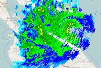
This radar loop from the Dominican Republic is a historical radar loop of Tropical Storm Franklin. Because the size of the imagery in this radar loop was large, it is only available on YouTube. This radar loop was recorded from the Dominican Institute of Civil Aviation. It starts on August 22nd, 2023 at 0:07Z and ends on August 25th, 2023 at 22:43Z.
Historical radar loops of Subtropical Storm Alpha (2020) making landfall in Portugal
These radar loops from Portugal are historical radar loops of Subtropical Storm Alpha. These radar loops show Alpha making landfall in Portugal. They were saved from the Portuguese Institute for Sea and Atmosphere. (Instituto Português do Mar e da Atmosfera, IPMA) They start on September 17th, 2020 at 18:10Z and end on September 18th, 2020 at 23:40Z.
This radar loop from the Bahamas is a historical radar loop of Hurricane Isaias. This radar loop shows Isaias crossing through parts of the Bahamas. The radar loop is about 22 megabytes. It was recorded from the Bahamas Department of Meteorology. It starts on July 31st, 2020 at 0:00Z and ends on August 3rd, 2020 at 14:00Z.
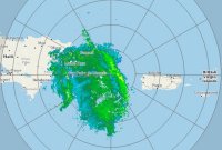
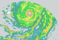
This radar loop from the Bahamas is a historical radar loop of Hurricane Dorian, which in 2019 became the strongest landfalling hurricane on record in the northwestern Bahamas. (according to the NHC's public advisory #33 on Dorian) This radar loop shows Dorian crossing over the Abaco Islands and Grand Bahama Island. The radar loop is about 35 megabytes. It was recorded from the Bahamas Department of Meteorology. It starts on August 31st, 2019 at 8:30Z and ends on September 4th, 2019 at 20:00Z.
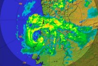
This Managua, Nicaragua radar loop is a historical radar loop of Hurricane Otto, which in 2016 became the southernmost landfalling hurricane in Central America on record. (according to the NHC's public discussion #16 on Otto) This radar loop shows Otto crossing Central America, through Nicaragua and Costa Rica. The radar loop is about 13 megabytes. It was recorded from the Nicaraguan Institute of Territorial Studies (Instituto Nicaragüense de Estudios Territoriales, INETER). It starts on November 24th, 2016 at 5:12Z and ends on November 25th, 2016 at 15:18Z.
Historical radar loop of Hurricane Dean (2007) making landfall in Mexico
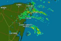
These radar loops from Mexico are historical radar loops of Hurricane Dean. These radar loops show Dean making landfall in Mexico. They were saved from Mexico's National Metereological Service (Servicio Meteorológico Nacional, SMN). The Cancun radar imagery starts at 5:16Z and continues through 15:55Z on August 21st, 2007. The Alvarado radar imagery starts at 9:01Z and continues through 20:31Z on August 22nd, 2007.
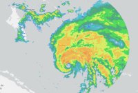
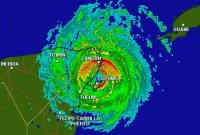
This Cancun, Mexico radar loop is a historical radar loop of Hurricane Wilma, which in 2005 became the most powerful hurricane, in terms of pressure, ever recorded in the Atlantic basin, with a pressure recorded at 884 mb. (estimated at 882 mb; according to NHC's tropical cyclone report on Wilma) This radar loop shows the entire landfall of Wilma on the Yucatan peninsula. The radar loop is about 14 megabytes. It was saved from Mexico's National Metereological Service (Servicio Meteorológico Nacional, SMN). It starts on October 20th, 2005 at 16:12Z when the eye entered the radars range and ends on October 24th, 2005 at 3:21Z when it left the radar.